


ste victoire

ja.13061965
User
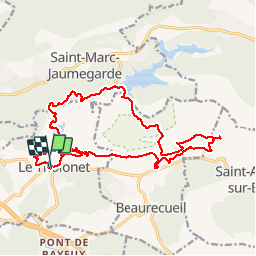

Length
21 km

Max alt
445 m

Uphill gradient
673 m
Km-Effort
30 km

Min alt
180 m

Downhill gradient
677 m
Boucle
Yes
Creation date :
2019-06-20 09:32:58.551
Updated on :
2019-06-20 09:32:58.952
3h09
Difficulty : Medium

FREE GPS app for hiking
 SityTrail
IGN / Geographical institutes
SityTrail Plus
The world is yours!
About
Trail Mountain bike of 21 km to be discovered at Provence-Alpes-Côte d'Azur, Bouches-du-Rhône, Le Tholonet. This trail is proposed by ja.13061965.
Description
Fabuleux
Positioning
Country:
France
Region :
Provence-Alpes-Côte d'Azur
Department/Province :
Bouches-du-Rhône
Municipality :
Le Tholonet
Location:
Unknown
Start:(Dec)
Start:(UTM)
702876 ; 4821829 (31T) N.
Comments